Travel Western North Carolina
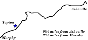
Following Wagon Trails - 1890s: Topton
Cherokee County
Altitude: 2,700 feet
In the 1880s and 1890s the area around Topton was known as Red Marble Gap. In the early 1880s the rail line being constructed from Asheville, N.C., would enter Cherokee County, N.C., via the gap, but only after considerable effort against the terrain and weather. In these two descriptions, the beauty of the mountains in the vicinity of Red Marble Gap is described.
The Widow Walker
New Haven Man in a North Carolina Hail Storm
“Valleytown, Cherokee County, N.C., April 15th, 1882. – Returning from a trip through Red Marble Gap into Swain County with a party of friends, we are forced by a pouring shower to seek shelter under the hospitable roof of the Widow Walker,... The party consists of two northern gentlemen now residing at Atlanta, the professor, your correspondent and the driver, a capital whip from Cleveland, Tennessee. Our outfit is a double-seated, side spring wagon, drawn by a pair of stout bay ponies. The professor is mounted on his four year old colt, a gentle but frisky beast. When overtaken by the shower he took his umbrella from the wagon (which in these parts is called a hack) and attempted to raise it. This was a new experience for the colt, and there was a lively contest between it and the professor... A shower among these mountains is a beautiful sight, even if one gets drenched by it. Ours had been following us eight miles before it caught us. We could see the great vaporous cloud moving rapidly along the high divide, wrapping one mountain peak after another in its fleecy folds, and extending itself over the valley until finally it enveloped us in a thick mist. Directly there was a rushing sound as of a strong wind; then the big drops began to splash about us, and shortly it came down in torrents. A bright fire was soon kindled, and sitting before it we were soon dry and warm again...”
- New Haven Register, published as New Haven Evening Register, April 21, 1882, p. 3.
From America’s Historical Newspapers – Early American Newspapers, an Archive of Americana Collection, published by Readex (Readex.com), a division of NewsBank.
“But in the Nantahala is to be found the most picturesque river of all this region. Its name signifies, in the Cherokee tongue, `Noonday sun,' from the fact that the mountains stand so closely about it that the sunlight only strikes it during the middle of the day. This river is in Macon county, and during most of its course it flows at the feet of precipitous crags, through vast forests and down inaccessible slopes.”
“A traveler thus describes a view of its valley after crossing Red Marble Gap: `The first view of it will cause you to rise in your stirrups. It is a narrow valley with one farmhouse lying in the foreground. Around it rises massive mountain walls perfectly perpendicular, veiled in woods and in height fully 2,000 feet. Directly before you is a parting of the tremendous ranges, and through this steep-sided gap, purple lines of mountains rising one behind the other, bar the vision. The picture of these far away ranges in the subdued coloring of distance, is of inspiring grandeur. The river is unseen at this point, but if the Cheowah mountain road is ascended, its white line of waters will be vislble as it issues from the wild gorge at the head of the valley, and bickering along between wood-fringed banks, at length disappears in the wilderness leading toward the great gap.’”
- Thomas H. Lindsey, Lindsey’s Guide Book to Western North Carolina (Asheville, N.C.: Randolph – Kerr Printing Co., 1890), pp. 12 – 13
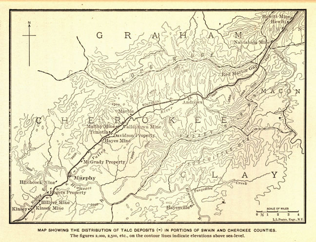
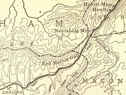
Red Marble Gap appears on the “Map Showing the Distribution of Talc Deposits in Portions of Swain and Cherokee Counties” that was published in Joseph Hyde Pratt’s Talc and Pyrophyllite Deposits in North Carolina. In this area of western North Carolina, as seen by the dotted lines on the map, five counties are in close proximity. These include Cherokee (lower left corner of the map), Clay (lower right corner), Graham (upper section of the map), Macon (center right on the map), and Swain (upper right). The elongated shape of the Valley River is discernable by the outline of Cherokee County.Concerning the talc deposits, Pratt noted that:
“As is shown by this map, the talc formation beginning in Swain county about six miles east of the Valley River mountains, follows up the valley of the Nantahala river to near the Macon county line, then up the Nelson creek ravine and crosses the mountains at an altitude of 2,800 feet at Red Marble Gap. Entering Cherokee county, it then follows down the valley of Valley river, broadening out near Andrews to a width of about one-half a mile . . . .” (p. 10)
 |
||
Return to the Southern Railway Map for the 1890s
Sources & Readings
- Cherokee County Historical Museum. A Pictorial History of Cherokee County. Murphy, N.C.: Cherokee County Historical Museum, 1995.
- Freel, Margaret Walker. Our Heritage, The People of Cherokee County, North Carolina, 1540 – 1955. Asheville, N.C.: Miller Print. Co., 1956 [c1957].
- Pratt, Joseph Hyde. Talc and Pyrophyllite Deposits in North Carolina. Raleigh: E.M. Uzzell, Public Printer and Binder, 1900.
- White, Alice, D., ed., and White, Nell A., associate ed. The Heritage of Cherokee County, North Carolina. Winston-Salem, N.C.: Cherokee County Historical Museum in cooperation with the History Division of Hunter Pub. Co., 1987.
- Williams, Michael Ann, essay, inventory, and photography; Dockery, Carl, ed. Marble & Log: The History & Architecture of Cherokee County, North Carolina. Murphy, N.C.: Cherokee County Historical Museum Council, Division of Archives and History, North Carolina Department of Cultural Resources, 1984.