Travel Western North Carolina
Following Wagon Trails - 1890s: Andrews
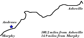
Cherokee County
Altitude: 1,800 feet
When traveling through Cherokee County on the Western North Carolina Railroad, which in 1894 would become the Murphy Branch of the Southern Railway, the passenger saw the landscape of the Valley River with its mountains and open, valley spaces. A number of communities are located along the river, including Tomotla, Marble, and Andrews. This column entitled “Valley River Dots” from the Murphy newspaper featured the area. The missing text is due to tears in the newspaper.
Valley River Dots
Tom____
There are two [___ls] of men now engaged in putting [through] the Maggie Kincaid cut, [____] here. Capt. Smith has offered [an] inducement to these men if [they] complete it this month.
The W.N.C.R. [__] have just completed a handsome depot at Tomotla and the [schedule] will be changed to make [it a] daily passenger train from Asheville run through to this point at once. The distance to Murphy from the station is only six miles.
Capt H.E. Smith, the supervisor of the work on the W.C.C. road, makes his headquarters at this place. He is a Virginian [of] the pure type. He says that some English and Northern capitalists have invested thirty million dollars in coal, iron and other lands in Virginia. He will go to his former home in Nelson county shortly to sell his property here.
- Cherokee Scout (Murphy, N.C.), October 21, 1890
On a Camping Trip
“Yesterday a party of young Columbians – Messrs. H. Green, F.L. Holland, Jr., A. McDougal and E. Joyner left for Western North Carolina, carrying tents and all other necessaries necessary to a camping trip on a search for fish and game in the vicinity of Andrews, N.C., which is near the Tennessee line. They expect to be out several weeks.”
- The State (Columbia, S.C.), July 9, 1895, p.2.
From America’s Historical Newspapers – Early American Newspapers, an Archive of Americana Collection, published by Readex (Readex.com), a division of NewsBank.
 |
||
Return to the Southern Railway Map for the 1890s
Sources & Readings
- Cherokee County Historical Museum. A Pictorial History of Cherokee County. Murphy, N.C.: Cherokee County Historical Museum, 1995.
- Freel, Margaret Walker. Our Heritage, The People of Cherokee County, North Carolina, 1540 – 1955. Asheville, N.C.: Miller Print. Co., 1956 [c1957].
- United States, Geological Survey. Geologic Atlas of the United States, “Nantahala Folio, North Carolina – Tennessee.” No. 143. Washington D.C.: U.S. Geological Survey, 1907.
- White, Alice, D., ed., and White, Nell A., associate ed. The Heritage of Cherokee County, North Carolina. Winston-Salem, N.C.: Cherokee County Historical Museum in cooperation with the History Division of Hunter Pub. Co., 1987.
- Williams, Michael Ann, essay, inventory, and photography; Dockery, Carl, ed. Marble & Log: The History & Architecture of Cherokee County, North Carolina. Murphy, N.C.: Cherokee County Historical Museum Council, Division of Archives and History, North Carolina Department of Cultural Resources, 1984.