Travel Western North Carolina
Motoring through the Mountains - 1930s
In 1939, the North Carolina State Highway and Public Works Commission (Raleigh, N.C.) issued its official map of “North Carolina Highways,” which illustrates changes in transportation as well as changes in the cultural and environmental landscape. Here, Cheoah Lake at Tapoco may be seen, although the future Lake Glenville and Lake Fontana are not yet represented. A number of communities on the “Highways” map were listed on earlier maps, but now have been relegated to lesser routes by road construction; meanwhile, communities such as Cherokee have become major destinations. The newly realized Great Smoky Mountains National Park is on this map, along with such prominent features as Gregory Bald, Clingmans Dome, Mt. LeConte, and Mt. Guyot. Finally, a trace outline of the Blue Ridge Parkway is visible on the map.
Motoring through the Mountains is the third geographically based timeline with illustrations of the region as it was in the 1930s.
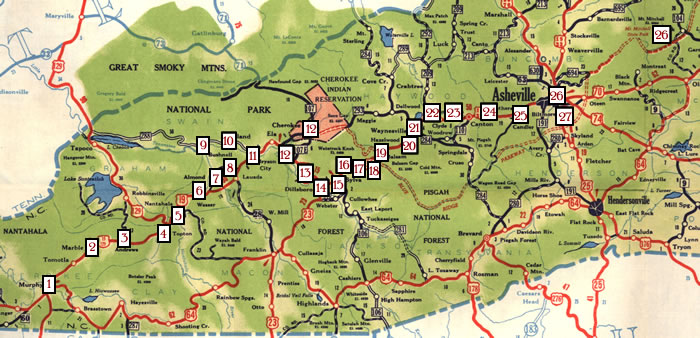
| 1. Murphy 2. Regal 3. Andrews 4. Topton 5. Nantahala 6. Hewitt 7. Almond |
8. Whiting 9. Bushnell 10. Forney 11. Bryson 12. Whittier (& side trip to Cherokee) 13. Wilmot 14. Dillsboro |
15. Sylva 16. Beta 17. Addie 18. Willits 19. Balsam 20. Hazelwood 21. Waynesville |
22. Tuscola 23. Clyde 24. Canton 25. Candler 26. Asheville (& side trip to Mt. Mitchell) 27. Biltmore |
Want to travel more? Follow wagon trails in the 1890s or Take the train in the 1910s.
Disclaimer: The items in this site are presented as part of the historical record and include historical materials that may contain negative stereotypes or language reflecting the culture or language of a particular period or place, including terminology that may not be deemed appropriate today.