Travel Western North Carolina
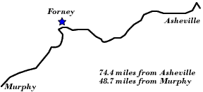
Motoring through the Mountains - 1930s: Forney
Swain County
Altitude: 1,550 feet
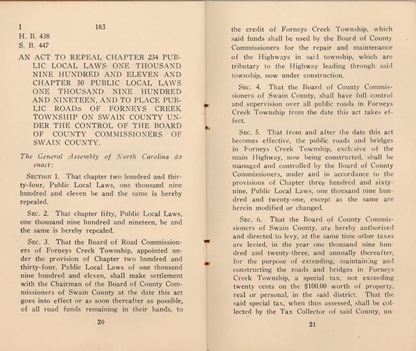
In 1923 the North Carolina General Assembly passed an act to repeal previous provisions concerning the construction and maintenance of roads in the Forneys Creek area of Swain County and to place the community under the governance of a county-wide authority. The act instructed the Board of Road Commissioners of Forneys Creek Township to “make settlement with the Chairman of the Board of County Commissioners of Swain County . . . of all road funds remaining in their hands, to the credit of Forneys Creek Township, which said funds shall be used by the Board of County Commissioners for the repair and maintenance of the Highways in said township, which are tributary to the Highway leading through said township, now under construction.” The act further instructed that “from and after the date this act becomes effective, the public roads and bridges in Forneys Creek Township, exclusive of the main Highway, now being constructed, shall be managed and controlled by the Board of County Commissioners . . . .” This act was included along with other laws concerning county roads in the booklet Road Laws of Swain County, 1923 (Observer Printing House, Charlotte, N.C.).
 |
||
Return to the Map for the 1930s
Sources & Readings
- Huddleston, Dale, ed. Swain County, N.C., Centennial, 1871 – 1971: Official Souvenir Centennial History. Waynesville, N.C.: The Mountaineer, [1971].
- Oliver, Duane. Along the River: People and Places. [S.l.]: Duane Oliver, 1998.
- Road Laws of Swain County, 1923 (Observer Printing House, Charlotte, N.C.).
- Swain County Genealogical and Historical Society. The Heritage of Swain County, North Carolina, 1988. Bryson City, N.C.: Swain County Historical and Genealogical Society, 1988.