Travel Western North Carolina
Taking the Train: Candler
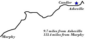
Buncombe County
Altitude: 2,120 feet
"Located beautifully in the very heart of a plateau teeming with the richest of agricultural resources, the surrounding scenery is a constant delight to the eyes of the observer, but is without that rugged grandeur which characterizes the mountains in Swain, Jackson and Haywood Counties.
"Swinging to the Northeast from Candler, the Railway successively touches the villages of Hominy, 8.7 miles from Asheville, Acton, 6 miles from Asheville, Sulphur Springs, 5.3 miles from Asheville, and Emma, 2.2 miles from Asheville, all of which are residential suburbs of the western North Carolina metropolis.
"Just beyond the little station of Emma, the Railway effects a junction with the Knoxville Division of the Southern Railway, crosses the French Broad River and over that division enters the station at Asheville. "
The 1916 tour guide Road Maps and Tour Book of Western North Carolina noted that:
“The road from Asheville to Waynesville, several hours by motor, is for the most part very good, and at Candler there is a branch-off into the Pisgah Motor Road, which takes one to the top of Mt. Pisgah. This road is a Government road, and, on account of its narrowness, parties have to go up the mountain in the morning and return in the afternoon.”
A year later in his article “Carolina’s Vacation Land” (Outing, July 1917), author Leroy L. Little recommended Mount Pisgah as a “must see” trip on a visit to western North Carolina, and commented:
“Mt. Pisgah National Game Preserve, 85,000 acres which was recently sold by the owners of Biltmore to the government, must have a day. It really ought to have more, for camping here can hardly be surpassed . . . . Pisgah is only nineteen miles from Asheville, a very pleasant run through country broken into easy though continuous grades and curves . . . . If you have nerves, some of the curves and grades up the mountainside will give them that semi-comfortable edge which you are just able to conceal from your companions.”
| To the West: Canton |  |
To the East: Asheville |
Return to the Southern Railway Map for the 1910s
Text excerpted from 1912 travel guide, The Western North Carolina Section at a Glance. Issued by the Passenger Traffic Department, Southern Railway, Premier Carrier of the South, Washington, D.C., 1912.
Sources & Readings
- North Carolina Good Roads Association. Road Maps and Tour Book of Western North Carolina. [Raleigh, N.C.?]: North Carolina Good Roads Association; in co-operation with the State Highway Commission, 1916 (Lynchburg, Va.: J.P. Bell).
- Swaim, Douglas, ed. Cabins & Castles: The History & Architecture of Buncombe County, North Carolina. City of Asheville, County of Buncombe: Division of Archives and History, North Carolina Department of Cultural Resources, 1981.
- Ward, Doris Cline, ed., Charles D. Biddix, associate ed. The Heritage of Old Buncombe County. Asheville, N.C.: Old Buncombe County Genealogical Society, 1981.