Travel Western North Carolina
Following Wagon Trails - 1890s: Whiting
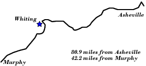
Swain County
Altitude: 1,560 feet
Railroad construction into western North Carolina’s mountain terrain posed a number of challenges to engineers. In addition to having to overcome the steepness of incline necessary to traverse the region, rail engineers also sought means of avoiding protracted detours while essentially paralleling rivers or their tributaries. One method employed was the use of tunnels to breach the mountains rather than follow the course of the river. Near the site of a later rail station that would be named Whiting was Indian Ridge Tunnel, a six hundred foot tunnel that allowed the railroad to avoid a bend in the Little Tennessee River. In other instances, as in the attempt to breach the mountains at Red Marble Gap into Cherokee County, N.C., the soil would prove too malleable to support a tunnel.
 |
||
Return to the Southern Railway Map for the 1890s
Sources & Readings
- Freel, Margaret Walker. Our Heritage, The People of Cherokee County, North Carolina, 1540 – 1955. Asheville, N.C.: Miller Print. Co., 1956 [c1957].
- George, Michael. Southern Railway’s Murphy Branch. Collegedale, Tenn.: The College Press, 1996.
- Gilbert, John F., ed. and comp. Crossties through Carolina: The Story of North Carolina’s Early Day Railroads. Raleigh, N.C.: Helios Press, 1969.
- Huddleston, Dale, ed. Swain County, N.C., Centennial, 1871 – 1971: Official Souvenir Centennial History. Waynesville, N.C.: The Mountaineer, [1971].
- Swain County Genealogical and Historical Society. The Heritage of Swain County, North Carolina, 1988. Bryson City, N.C.: Swain County Historical and Genealogical Society, 1988.