Travel Western North Carolina
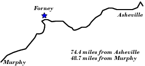
Following Wagon Trails - 1890s: Forney
Swain County
Altitude: 1,550 feet
Wilbur G. Zeigler and Ben S. Grosscup provided a description of the Forney Creek area in their travel account The Heart of the Alleghanies, published in 1883, on pages 129 - 130. The Charleston referred to in this instance is the community that would later be known as Bryson City, N.C. A “corncracker” is a small mill used for grinding corn.
“Forney creek empties into the Tuckasege at some distance below Charleston. The ride to its mouth will interest even the most practical of travelers. At times, the waters create a tumultuous uproar over a broken channel; then with startling silence they run smooth and swift for a hundred yards, and, making a bold sweep around a craggy mountain, disappear as though the earth had swallowed them. There are several islands in the stream; and at one place there is a twin pair lying close together in a channel wider than usual. Wild ducks will often be seen keeping their unwavering flight around the bends; . . . . The mail man, mounted on a cadaverous horse, with leather mailbags upon his saddle, is apt to meet the tourist; but, differing from the general run of the natives, he travels on time and is loath to stop and talk. Not so with the man who, with a bushel of meal over his shoulders, is coming on foot from the nearest “corn-cracker.” As you halt for a few points in regard to your route, he will answer to the best of his ability; and then, if you feel so inclined, he will continue planted in the road and talk for an hour without once thinking of setting down his load. The fishing in Forney creek is excellent. It is a rugged section, and at its mouth the scenery is wild enough to hold forth fine inducements. Hazel and Eagle creeks empty into the Little Tennessee in a still more lonely and less inhabited section, a number of miles below the mouth of the Tuckasege.”
- Wilbur G. Zeigler and Ben S. Grosscup. The Heart of the Alleghanies (Raleigh, N.C.: A. Williams & Co.; Cleveland, O.: W.W. Williams, 1883), pp. 129 – 130.
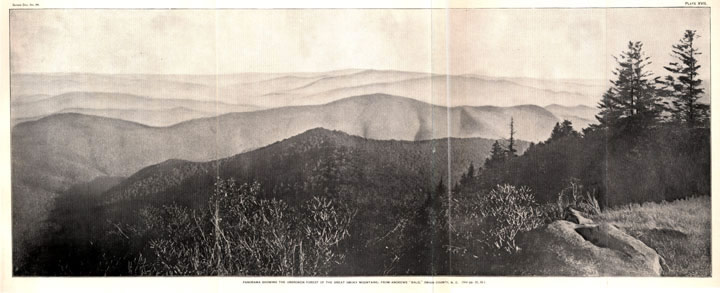
The vistas offered from western North Carolina’s mountain peaks were highlighted by this foldout view in a 1902 report on Forests, Rivers and Mountains of the Southern Appalachian Region. The scene was captioned “Panorama Showing the Unbroken Forest of the Great Smoky Mountains; from Andrews `Bald,’ Swain County, N.C.” A bald is a high elevation, grassy area found in the mountains. Andrews Bald is located near Forney Creek and now in the Great Smoky Mountains National Park.
 |
||
Return to the Southern Railway Map for the 1890s
Sources & Readings
- Farwell, Harold, Jr. and J. Karl Nicholas. Smoky Mountain Voices: A Lexicon of Southern Appalachian Speech Based on the Research of Horace Kephart.
- Huddleston, Dale, ed. Swain County, N.C., Centennial, 1871 – 1971: Official Souvenir Centennial History. Waynesville, N.C.: The Mountaineer, [1971].
- Montgomery, Michael B. and Joseph S. Hall. Dictionary of Smoky Mountain English. Knoxville: University of Tennessee Press, 2004.
- Powell, William S. The North Carolina Gazetteer. Chapel Hill: University of North Carolina Press, 1968.
- Swain County Genealogical and Historical Society. The Heritage of Swain County, North Carolina, 1988. Bryson City, N.C.: Swain County Historical and Genealogical Society, 1988.
- United States, Department of Agriculture. Message from the President of the United States Transmitting a Report of the Secretary of Agriculture in Relation to the Forests, Rivers and Mountains of the Southern Appalachian Region. Washington: Government Printing Office, 1902.
- Zeigler, Wilbur G. and Ben S. Grosscup. The Heart of the Alleghanies; Or, Western North Carolina; Comprising Its Topography, History, Resources, People, Narratives, Incidents, and Pictures of Travel, Adventures in Hunting and Fishing and Legends of Its Wilderness. Raleigh, N.C.: A. Williams & Co.; Cleveland, O.: W.W. Williams, 1883.